1. Pile group settlement Analysis
The settlement behavior of a pile group has long been known to differ from the settlement of a single pile. A number of methods have been proposed to estimate the settlement of pile groups. Some of the methods give the maximum total settlement of pile group (refer as type A) while some other methods have capabilities to determine settlement distribution (refer as type B). The equivalent raft method (Poulos 1993; Terzaghi and Peck 1948; Tomlinson 1977) is one of the most famous methods to determine the settlement of pile groups that falls under type A. Other empirical methods that are employed for the settlement of shallow foundations (De Beer and Martens 1957; Schmertmann 1970) can also be used to determine the settlement of the pile group by assuming that the pile group can be replaced with an equivalent raft located at the specific depth below cut off level.
Poulos's pile interaction method (Poulos 1968; Poulos and Mattes 1971; Poulos and Davis 1980) has capabilities of determining settlement distribution beneath the construction. However, the pile interaction method is limited to a single homogeneous soil layer which is rarely encountered.
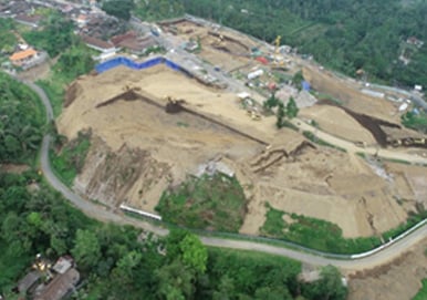
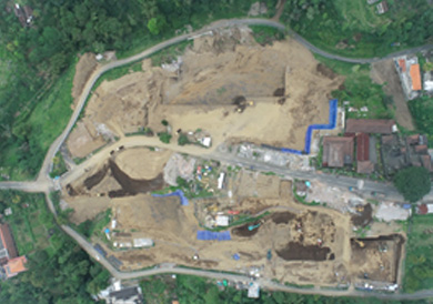
Due to the recent development in construction technologies, it is no longer rare for a building to be constructed on top of a mountain which involves a number of cut and fill processes as shown in Figure 1. Based on the in‑situ test conducted at the site, the soil layer is non-uniform as indicated in Figure 2. Hence, the analysis becomes very complicated when the construction process, soil surface geometry, and non‑horizontal soil layers are considered.
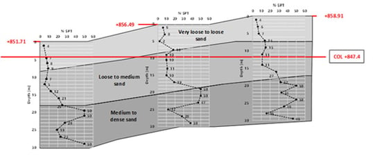 Figure 2_ Soil Layer at the site
2. midas GTS NX for Geometry Maker
Geometry construction becomes one of the main challenges for conducting 3D analysis. Several methods that can be used in MIDAS to help constructing the geometry is as follow:
1. Terrain Geometry Maker (TGM)
2. Bedding Plane
3. Divide Mesh
Terrain geometry maker (TGM) is one of the powerful add ins in MIDAS GTS NX which has the capabilities to convert contour line into a surface as shown in Figure 3. Combining TGM with other third party software which has capabilities to conduct spatial interpolation and obtaining contour line, it is possible to construct Surface layer, phreatic surface and also soil layering into the GTS NX.
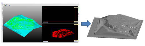 Figure 3_ Terrain geometry maker (TGM)
When third party software is not available, it is possible to use bedding plane (Figure 4) to conduct spatial interpolation and hence obtaining soil surface to soil layers. Bedding plane makes it convenient to import soil layer from boreholes for 3D analysis purposes. However, it is sometimes difficult to control spatial interpolation and hence additional dummy or control points are required to ensure the soil layer is according to the user desired.

You can check more of these details in the download file.
3. Comparison between Full Scale Model and Simplified Model
4. Conclusion
Author